Difference between revisions of "Teams Winter 2011/team1/BlackBerry/Add Mapping Option"
| (8 intermediate revisions by the same user not shown) | |||
| Line 1: | Line 1: | ||
=== 10. Add Mapping Option === | === 10. Add Mapping Option === | ||
| + | '''*NOTE:''' In order to test this feature the newest version of the simulator must be installed<br/> | ||
10.1. In order to implement Address Locator we need to add address field and getter/setter methods to <code>Student</code> class: | 10.1. In order to implement Address Locator we need to add address field and getter/setter methods to <code>Student</code> class: | ||
<source lang="java"> | <source lang="java"> | ||
| Line 60: | Line 61: | ||
{ | { | ||
Student student = (Student) _keywordFilterField.getSelectedElement(); | Student student = (Student) _keywordFilterField.getSelectedElement(); | ||
| − | + | ||
| − | + | if(student != null) | |
| − | + | { | |
| − | + | try | |
| − | + | { | |
| − | + | String address = student.getAddress(); | |
| − | + | showAddress(address); | |
| − | + | ||
| − | + | } catch(LocatorException ex){ | |
| − | + | Dialog.alert("cannot get location: " + ex.getMessage()); | |
| − | + | } | |
| − | + | catch(Exception ex){ | |
| − | + | Dialog.alert("map application is not available: "+ ex.getMessage()); | |
| − | + | } | |
| − | + | } | |
| − | |||
| − | |||
| − | |||
| − | |||
| − | |||
| − | |||
| − | |||
| − | |||
| − | |||
| − | |||
} | } | ||
| − | + | })); | |
| − | |||
</source> | </source> | ||
| + | 10.5. Implement <code>showAddress()</code> method. The <code>Locator.geocode()</code?> method must be in another thread: | ||
| + | <source lang="java"> | ||
| + | public void showAddress(String adrs)throws LocatorException{ | ||
| + | final String address = adrs; | ||
| + | new Thread(new Runnable(){ | ||
| + | public void run(){ | ||
| + | try { | ||
| + | Landmark[] landm = Locator.geocode(address, null); | ||
| + | |||
| + | MapsArguments ma = new MapsArguments(landm); | ||
| + | Invoke.invokeApplication(Invoke.APP_TYPE_MAPS, ma); | ||
| + | } catch (Exception ex) { | ||
| + | Dialog.alert("Exception when getting location: " + ex.getMessage()); | ||
| + | } | ||
| + | } | ||
| + | }).start(); | ||
| + | |||
| + | } | ||
| + | </source> | ||
| + | 10.6. Change the ''Run Configuration ''in order to show maps:<br/> | ||
| + | [[Image: BB_conf1.png | 500px]]<br/> | ||
| + | and<br/> | ||
| + | [[Image: BB_conf2.png | 500px]]<br/> | ||
| + | 10.7. Run the application, selected a Student and from the menu select '''Address on Map''':<br/> | ||
| + | |||
| + | [[Image: BB_map1.png | 300px]] | ||
| + | [[Image: BB_map2.png | 325px]] | ||
Latest revision as of 20:01, 12 April 2011
10. Add Mapping Option
*NOTE: In order to test this feature the newest version of the simulator must be installed
10.1. In order to implement Address Locator we need to add address field and getter/setter methods to Student class:
  public Student(String firstName, String lastName, String email, String address) {
      this.firstName = firstName;
      this.lastName = lastName;
      this.email = email;
      this.email = address; //add address field
   }

   public String getAddress(){
      return address;
   }
   public void setAddress(String address){
      this.address = address;
   }
10.2. Add EditTextFields to Add, Edit and view option:
viewItem
   BasicEditField addressField = new BasicEditField("address: ",student.getAddress(),50,Field.NON_FOCUSABLE);
   addressField.setBorder(roundedBorder);
   addressField.setBackground(solidBackground);
   add(addressField);
addItem
   EditField inputField4 = new EditField("Student's address: ","");
   addDialog.add(inputField4);

   // Display the dialog and add a new element to the list
   if(addDialog.doModal() == 0) {
     addElementToList(new Student(inputField1.getText(),inputField2.getText(),inputField3.getText(), inputField4.getText()));
   }
editItem
  EditField inputField4 = new EditField("Address: ",studentOld.getAddress());
  editDialog.add(inputField4);

  if(editDialog.doModal() == 0)
    {
      studentNew.setFirstName(inputField1.getText());
      studentNew.setLastName(inputField2.getText());
      studentNew.setEmail(inputField3.getText());
      studentNew.setAddress(inputField4.getText()); //set Address
      editListElement(studentOld, studentNew);
    }
10.3. Add the Map Option to the manu:
   //Show the address on the map
   ImageMenuItem mapItem = new ImageMenuItem("Address on Map", 500, 5, MENU_MAP);
   _mainScreen.addMenuItem(mapItem);
10.4. Implement address locator:
   mapItem.setCommand(new Command(new CommandHandler(){
      public void execute(ReadOnlyCommandMetadata metadata, Object context)
      {
         Student student = (Student) _keywordFilterField.getSelectedElement();

                if(student != null)
                {
                    try
                    {
                        String address = student.getAddress();
                        showAddress(address);

                    } catch(LocatorException ex){
                        Dialog.alert("cannot get location: " + ex.getMessage());
                    }
                    catch(Exception ex){
                        Dialog.alert("map application is not available: "+ ex.getMessage());
                    }
                }
            }
        }));
10.5. Implement showAddress() method. The Locator.geocode()</code?> method must be in another thread:
  public void showAddress(String adrs)throws LocatorException{
     final String address = adrs;
     new Thread(new Runnable(){
        public void run(){
        try {
           Landmark[] landm = Locator.geocode(address, null);

           MapsArguments ma = new MapsArguments(landm);
           Invoke.invokeApplication(Invoke.APP_TYPE_MAPS, ma);
         } catch (Exception ex) {
           Dialog.alert("Exception when getting location: " + ex.getMessage());
         }
       }
     }).start();

   }
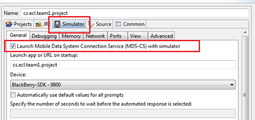
10.6. Change the Run Configuration in order to show maps:

and

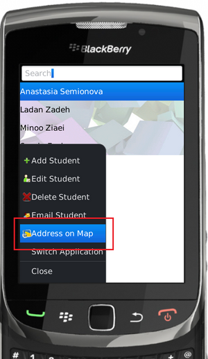
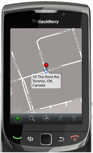
10.7. Run the application, selected a Student and from the menu select Address on Map:

